March 2019 Water Conditions Summary
Hydrologic data from 28 wells and 33 streamgages were used to monitor the monthly groundwater and streamflow response to weather conditions in Maryland, Delaware, and the District of Columbia. In March 2019, groundwater levels were at record March highs at eight wells and above normal at 79 percent of the wells. Monthly mean streamflow was above normal at 64 percent of the streamgages.
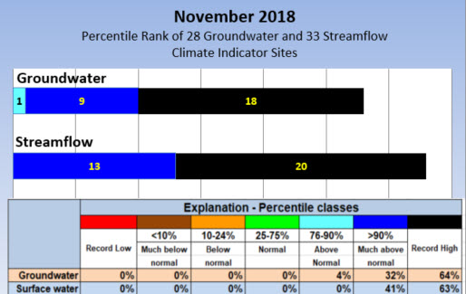
The number of groundwater and surface-water sites, and the percentage of the total number of groundwater and surface-water sites that fall within each percentile range, are shown in the graph for March 2019.
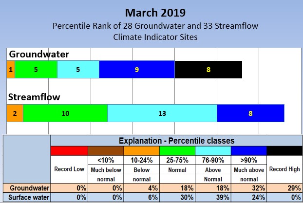
*A percentile is a value on a scale from 0 to 100 that indicates the percent of a distribution that is equal to or below it. A percentile between 25 and 75 is considered normal. For example, a groundwater level in the 90th percentile is equal to or greater than 90 percent of the values recorded for that month.
To view more detailed information about Monthly Water Conditions in Maryland, Delaware, and the District of Columbia, use the navigation menu on the left.
 Click Here for the Printable PDF of the
Current Monthly Water Conditions report
Why is it important for the USGS to collect and analyze water resources data?
USGS water data are valuable to the public, researchers, water managers, planners, and agricultural users, especially during extreme conditions like floods and droughts. The USGS is known for its consistent measurement techniques and the most extensive set of historical groundwater and streamflow data available to the public. Since these long-term data were collected during wet and dry periods, they can be used to assess how water resources respond to changes in weather, and to evaluate how current data compare to the historical data. The uniformity of the dataset enables multi-state comparisons and other comparative statistical analyses that can better inform policy makers of possible water-resources conditions they might encounter in the future.
The sites used in this water summary were carefully selected to include long-term datasets and show the response of streamflow and groundwater levelsto weather conditions, rather than the effects of human influences. Of the USGS sites presented in this summary,13 wells and 32 streamgages have more than 50 years of data. The current streamflow and groundwater data are ranked in comparison to the historical record and summarized. In addition to groundwater and streamflow data, this summary includes precipitation data to give a more complete picture of the region’s water resources and the monthly freshwater flow to the Chesapeake Bay. Hydrologic and weather data have not been reviewed and are therefore provisional and subject to revision.