Water Science for Maryland, Delaware and the District of Columbia
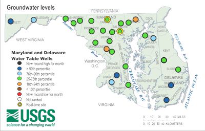
USGS Groundwater DataGroundwater is water that flows or seeps downward and saturates soil or rock, supplying springs and wells. Groundwater often begins as precipitation and soaks into the ground where it is stored underground in rock crevices and in the pores of geologic materials (these are aquifers), the same way as water fills a sponge. The upper surface of the saturated zone is called the water table. Monthly Groundwater Level
Real-Time GroundwaterView Real-Time Groundwater Wells by Region:
The Real-Time Groundwater Level Network contains water level data that is typically recorded every 15-60 minutes, and transmitted to USGS offices every few hours. Transmissions may be more frequent during critical events. * Note: This is provisional data and is subject to revision. Click here to view the Real-Time Groundwater Network Click here to view the region-wide Groundwater Real-Time Table | ||||||

![]() U.S. Department of the Interior |
U.S. Geological Survey
U.S. Department of the Interior |
U.S. Geological Survey
URL: https://md.water.usgs.gov/waterdata/index.html
Page Contact Information: webmaster@md.water.usgs.gov
Page Last Modified:
Friday, October 24, 2014