|
|
|
||||
| USGS Potomac River Streamflow |
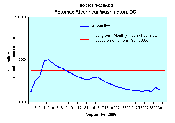
USGS 01646500 Potomac River near Washington, DC
Provisional data from the U.S. Geological Survey, in cooperation with the States of Maryland, Pennsylvania, and Virginia.
September 2006: Streamflow on the Potomac River in September was 5% above normal. The lowest flow was 2,730 cfs on September 1. The highest flow was 15,370 cfs on September 5.
Monthly Mean Daily Streamflow for the Potomac River at Washington, DC in cubic feet per second (cfs) ***** Preliminary Data Subject To Revision ***** |
|||||||
Mean Daily |
Average* |
% of Average |
High |
Low |
|||
| January | 20,400 |
14,300 |
143% |
34,500 |
1/5/06 |
13,000 |
1/13/06 |
| February | 15,400 |
17,700 |
87% |
18,100 |
2/7/06 |
5,780 |
2/28/06 |
| March | 5,940 |
24,000 |
25% |
8,270 |
3/1/06 |
4,620 |
3/31/06 |
| April | 10,700 |
20,700 |
52% |
35,400 |
4/25/06 |
4,600 |
4/1/06 |
| May | 7,900 |
15,200 |
52% |
13,290 |
5/18/06 |
2660 |
5/31/06 |
| June | 16,800 |
10,000 |
168% |
50,000 |
6/29/06 |
1,540 |
6/22/06 |
| July | 7,960 |
5,560 |
143% |
30,800 |
7/1/06 |
3,850 |
7/31/06 |
| August | 2,300 |
5,300 |
43% |
3,570 |
8/1/06 |
1,670 |
8/27/06 |
| September | 5,880 |
5,600 |
105% |
15,370 |
9/5/06 |
2,730 |
9/1/06 |
| October | 6,760 |
||||||
| November | 8,050 |
||||||
| December | 11,900 |
||||||
*Based on data from 1937-2005.
See the links below for additional streamflow information for the Potomac River near Washington, DC
Real-time streamflow
5-year hydrograph
Historical streamflow
| AccessibilityFOIAPrivacyPolicies and Notices | |
 |
|