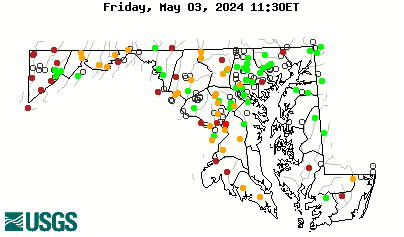
Local Number |
Well Depth |
aquifer |
Period of Record |
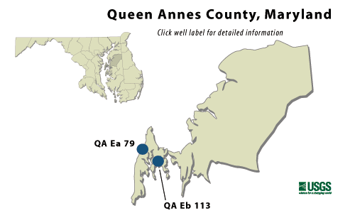
| QA Ea 79 | 298 ft |
Aquia Formation of Upper Paleocene age |
April 1985 to current year |
| QA Eb 113 | 216 ft |
Aquia Formation of Upper Paleocene age |
October 1982 to current year |
QA Ea 79
NWIS Historical Levels
QA Ea 79 on Groundwater Watch
|
WELL NAME |
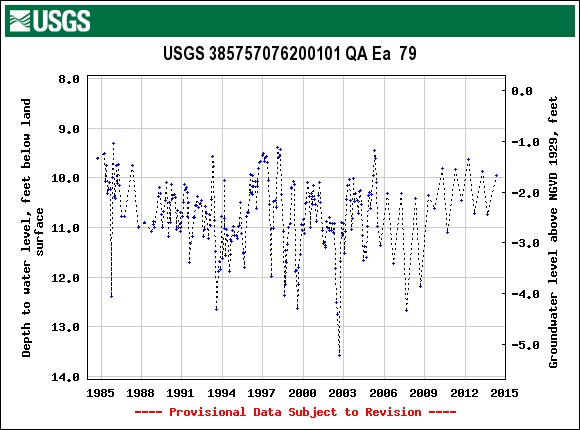
QA Ea 79 |
|
SITE ID |
385757076200101 |
|
LOCATION |
Lat 38°57´57", long 75°20´01", Hydrologic Unit 02060002, at Mowbray Park, Kent Island. Owner: Maryland Geological Survey. |
|
AQUIFER |
Aquia Formation of Upper Paleocene age. Aquifer code: 125AQUI. |
|
INSTRUMENTATION |
Monthly measurements with electric tape by U.S. Geological Survey personnel. Measured twice yearly fromOctober 1986 to April 1989. |
|
CHARACTERISTICS |
Drilled, observation, artesian well, depth 298 ft; casing diameter 4 in., to 288 ft; screen diameter 4 in from 288 to 298 ft. |
|
DATUM |
Elevation of land surface is 8.3 ft above sea level. Measuring point: Top of casing, 2.31 ft above land surface. |
|
REMARKS |
Kent Island Groundwater monitoring network well. Water levels are affected by nearby Groundwater withdrawals. |
|
PERIOD OF RECORD |
April 1985 to current year. |
|
EXTREMES FOR RECORD |
Highest water level measured, 9.30 ft below land surface, Dec. 2, 1985; lowest measured, 12.65 ft below land surface, Aug. 3, 1993. |
|
COOPERATORS |
Maryland Geological Survey |
|
Download
the data for the entire
period of record for this
well |
|
QA Eb 113
NWIS Historical Levels
QA Eb 113 on Groundwater Watch
WELL NAME |
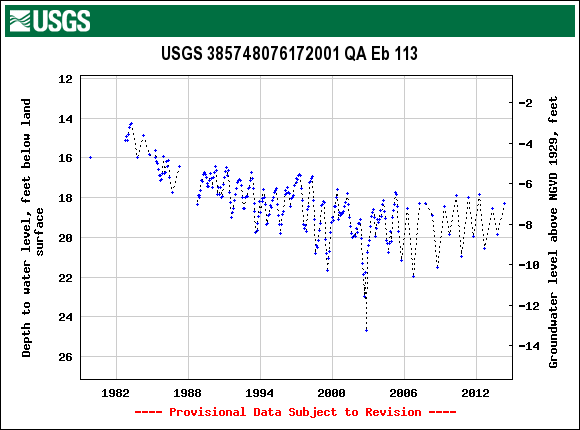
QA Eb 113 |
SITE ID |
385748076172001 |
|
LOCATION |
Lat 38°57´48", long 76°17´20", Hydrologic Unit 02060001, near Chester, Kent Island. Owner: U.S. Geological Survey. |
|
AQUIFER |
Aquia Formation of Upper Paleocene age. Aquifer code: 125AQUI. |
|
INSTRUMENTATION |
Monthly measurements with electric tape by U.S. Geological Survey personnel. Equipped with graphic water- level recorder from June 30, 1986 to October 2, 1994. |
|
CHARACTERISTICS |
Drilled, observation, artesian well, depth 216 ft; casing diameter 6 in., to 176 ft; screen diameter 6 in from 176 to 216 ft. |
|
DATUM |
Elevation of land surface is 11.34 ft above sea level. Measuring point: Top of casing, 2.60 ft above land surface. |
|
REMARKS |
Kent Island Groundwater monitoring network well. Water levels are affected by nearby Groundwater withdrawals. |
|
PERIOD OF RECORD |
October 1982 to current year. |
|
EXTREMES FOR RECORD |
Highest water level measured, 14.05 ft below land surface, April 18, 1989; lowest measured, 21.68 ft below land surface, Aug. 4, 1999. |
|
COOPERATORS |
Maryland Geological Survey |
|
Download
the data for the entire
period of record for this
well |
|