Local Number |
Well Depth |
aquifer |
Period of Record |
| CE Ee 29 | 547 ft |
Potomac Group of Lower Cretaceous age |
From August 1978 |
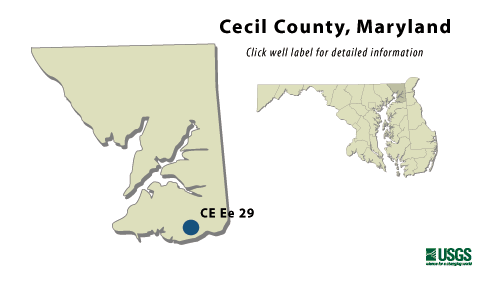
CE Ee 29
NWIS Historical Levels
CE Ee 29 on Groundwater Watch
|
WELL NAME |
CE Ee 29 |
|
SITE ID |
392403075521801 |
|
LOCATION |
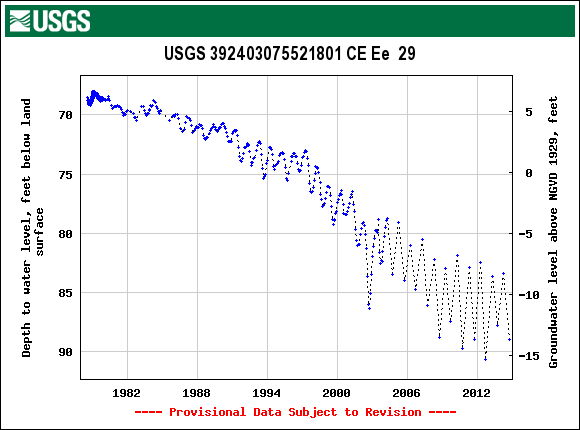
Lat 39°24´03", long 75°52´18", Hydrologic Unit 02060002, 0.3 mi southwest of MD Rts. 213 and 282, Cecilton. Owner: U.S. Geological Survey. |
|
AQUIFER |
Upper Patapsco of Lower Cretaceous age. Aquifer code: 217PPSCU. |
|
INSTRUMENTATION |
Monthly measurements with electric tape by U.S. Geological Survey personnel. Equipped with a digital water-level recorder from Aug. 22, 1979 to Dec. 4, 1979. |
|
CHARACTERISTICS |
Drilled, observation, artesian well, depth 547 ft; casing diameter 10 in., to 158 ft; casing diameter 4 in., to 515 ft and 525 to 547 ft; screen diameter 4 in. from 515 to 525 ft. |
|
DATUM |
Elevation of land surface is 75 ft above National Geodetic Vertical Datum of 1929, from topographic map. Measuring point: Top of casing, 2.35 ft above land surface. |
|
REMARKS |
Maryland Water-Level Network observation well. |
|
PERIOD OF RECORD |
August 1978 to current year. |
|
EXTREMES FOR RECORD |
Highest water level measured, 67.99 ft below land surface, March 25, 1979; lowest measured, 79.21 below land surface, Sept. 2, 1999. |
|
COOPERATORS |
Maryland Geological Survey |
|
Download
the data for the entire
period of record for this
well |
|