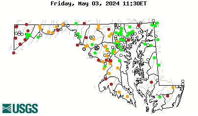
Local Number |
Well Depth |
aquifer |
Period of Record |
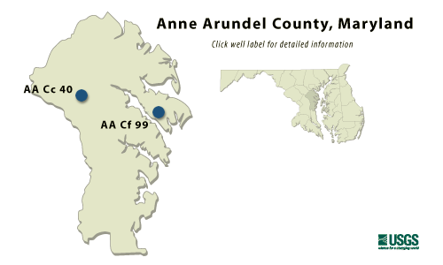
| AA Cc 40 | 238 ft |
Lower Patapsco aquifer in the Patapsco Formation of Lower Cretaceous age |
December 1959- current year |
| AA Cf 99 | 220 ft |
Magothy Formation of Upper Cretaceous age |
January 1971 to current year |
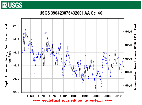
AA Cc 40
NWIS Historical Levels
AA Cc 40 on Groundwater Watch
| WELL NAME |
AA Cc 40 |
| SITE ID |
390423076432001 |
| LOCATION |
Lat 39°04´23", long 76°43´20", Hydrologic Unit 02060006, on Rifle Range Rd., For George G. Meade. Owner: U.S. Army. |
|
AQUIFER |
Lower
Patapsco aquifer in the
Patapsco Formation of |
|
INSTRUMENTATION |
Monthly measurements with
electric tape by U.S. Geological
Survey personnel. Equipped
with graphic |
|
CHARACTERISTICS |
Drilled, observation, artesian well, depth 238 ft; casing diameter 6in, to 208 ft; screened diameter 6 in, from 208 to 238 ft. |
|
DATUM |
Altitude
of land surface is 136.92
ft above sea level. |
|
REMARKS |
Maryland Water-Level Network observation well. Water levels are affected by local groundwater withdrawal. |
|
PERIOD OF RECORD |
December 1959 to current year. |
|
EXTREMES FOR RECORD |
Highest water level measured, 42.58 ft below land surface, March 25, 1961; lowest measured, 51.69 ft below land surface, Sept. 1, 1992. |
|
COOPERATORS |
Maryland Geological Survey |
|
Download
the data for the entire
period of record for this
well |
|
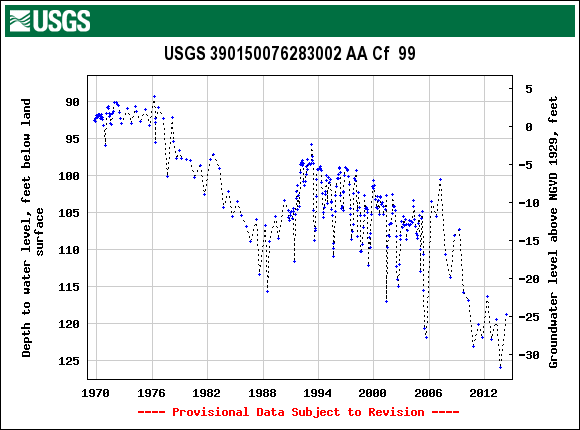
AA Cf 99
NWIS Historical Levels
AA Cf 99 on Groundwater Watch
| WELL NAME |
AA Cf 99 |
| SITE ID |
390150076283002 |
|
LOCATION |
Lat 39°01´50", long 76°28´30", Hydrologic Unit 02060004, 3.1 mi northeast of Annapolis, near Anne Arundel Co. Traffic Engineering Building, Broad Neck. Owner: Anne Arundel Co. Dept. of Recreation and Parks. |
|
AQUIFER |
Magothy Formation of Upper Cretaceous age. Aquifer code: 211MGTY. |
|
INSTRUMENTATION |
Monthly measurements with electric tape by U.S. Geological Survey personnel. Equipped with graphic water-level recorder from Sept. 28, 1969 to July 13, 1971. |
|
CHARACTERISTICS |
Drilled, artesian, observation well, depth 220 ft; casing diameter 2 in, to 210 ft; screened diameter 2 in, from 210 to 220 ft. |
|
DATUM |
Altitude of land surface is 93.70 ft above sea level. Measuring point: Top of casing, 3.60 ft above land surface. |
|
REMARKS |
Maryland Water-Level Network observation well. Water levels are affected by local groundwater withdrawal. |
|
PERIOD OF RECORD |
January 1971 to current year. |
|
EXTREMES FOR RECORD |
Highest water level measured, 89.29 ft below land surface, April 13, 1976; lowest measured, 115.65 ft below land surface, July 11, 1988. |
|
COOPERATORS |
Maryland Geological Survey |
|
Download
the data for the entire
period of record for this
well |
|