Water Science for Maryland, Delaware and the District of Columbia
|
Home
| |||||||||||
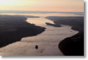
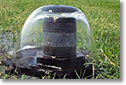
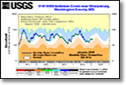
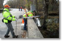
USGS Water Data and InformationU.S. Geological Survey (USGS) water data and information is valuable to the public, researchers, water managers, planners, and agricultural users, especially during floods and droughts. Scientists at the USGS have measured streamflow and groundwater levels to assess water resources since 1879. The USGS provides the most extensive set of historical streamflow and groundwater data available to the public. Water data is quality assured by employing standardized techniques used across the country. The uniformity of the dataset allows for multi-state comparisons and other comparative statistical analyses that inform policy makers of water resource availability and quality.
| |||||||||||

![]() U.S. Department of the Interior |
U.S. Geological Survey
U.S. Department of the Interior |
U.S. Geological Survey
URL: https://md.water.usgs.gov/waterdata/index.html
Page Contact Information: webmaster@md.water.usgs.gov
Page Last Modified:
Friday, October 24, 2014