USGS - science for a changing world

MD-DE-DC Water Science Center

Home >> Water Data >> Streamflow Statistics >> Choptank River near Greensboro, MD (01491000)

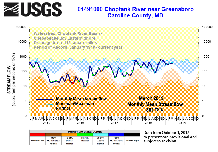
Streamflow Statistics - Choptank River near Greensboro, MD (01491000)

Five Year Hydrographs

Choptank River

This is a real-time site. Click to view real-time data.

Site Characteristics

LOCATION
Latitude 38°59'49.9", Longitude 75°47'08.9" NAD83,
Caroline County, Maryland , Hydrologic Unit 02060005
DRAINAGE AREA 113 square miles
GAGE Datum of gage is 3.51 feet above sea level NGVD29
STATION TYPE Surface Water
STATION DATA
Data Type Begin Date End Date Count
Real-time This is a real-time site
Peak streamflow 1948-01-14 2001-06-17 54
Daily streamflow 1948-01-01 2001-09-30 19632
Water Quality Samples 1964-06-11 2001-09-10 1021
SITE OPERATION Site is located in Maryland; record is maintained by the USGS Maryland Water Science Center
COOPERATORS Funding for the operation of this station is provided by the
the U.S Geological Survey.
CONTACT INFORMATION Email questions about this station to:
gs-w md_NWISWeb_Data_Inquiries@usgs.gov

Accessibility FOIA Privacy Policies and Notices

Take Pride in America logo USA.gov logo U.S. Department of the Interior | U.S. Geological Survey
URL: http://md.water.usgs.gov/surfacewater/streamflow/choptank.html
Page Contact Information: webmaster@md.water.usgs.gov
Page Last Modified: Thursday, November 05, 2009