USGS - science for a changing world

MD-DE-DC Water Science Center

Home >> Water Data >> Groundwater >> Water-Table Wells >> Charles County, MD

Conditions as of October 2009

Map of Maryland and Delaware counties, name labeled, clickable imagemap

Local Number

Well Depth 

Aquifer

Period of Record

CH Bg 12 24.5 ft Calvert Fm - Northern Atlantic Coastal Plain aquifer system August 1983 - present
CH De 45 25.5 ft Quarternary Alluvium August 1983 - present

CH Bg 12

Click to access historical data for CH Bg 12

  • Return to Top of Page

CH De 45

Click to access historical data for CH De 45

  • Return to Top of Page

Accessibility FOIA Privacy Policies and Notices

Take Pride in America logo USA.gov logo U.S. Department of the Interior | U.S. Geological Survey
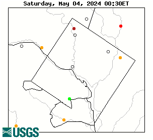
URL: http://md.water.usgs.gov/groundwater/web_wells/current/water_table/counties/charles/index.html
Page Contact Information: webmaster@md.water.usgs.gov
Page Last Modified: Thursday, November 05, 2009