
Hydrogeology and Groundwater Quality of the Anacostia River Watershed
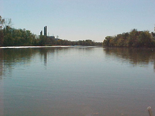
The Anacostia Watershed in District of Columbia is an urban watershed with a long history of industrial and residential development. For over 200 years, the Anacostia River has been subjected to dredging, filling, contamination, and other human influences, which have contaminated the river and groundwater.
Groundwater hydrogeology in the lower Anacostia tidal watershed is complex and not easily characterized. To address the environmental problems and increase the understanding of the hydrogeologic framework, including groundwater/surface-water interactions, and estimates of the contributions of contaminants from groundwater to the lower tidal Anacostia River, the Anacostia groundwater project collects groundwater quantity and quality data. Investigating paleochannels is another tool being used to help understand the groundwater flow. A tide gage has been installed to help examine the groundwater/surface water interactions.
The U.S. Geological Survey (USGS) in cooperation with the District Department of Energy and the Environment (DOEE) has been studying groundwater in the Anacostia Watershed since 2002.
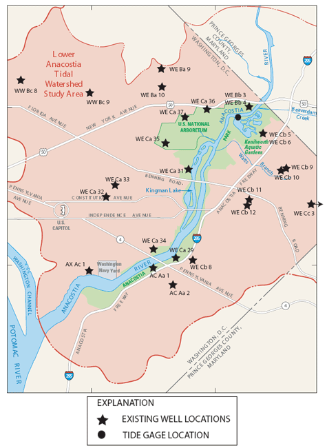
Study Location and Site Information
Click a site on the map below to view more information. (The link will take you to a NWISWeb page.)
Project Activities
The proposed project is a multi-year investigation designed to use existing data and to collect new data to achieve the objective in a cost-effective manner. The following approach is proposed to help achieve the objective:
-
Develop a series of hydrogeologic cross sections in the lower Anacostia tidal watershed. Because this is a highly urbanized area, it is anticipated that a lot of engineering information on the geology of the area will be available in the records of various public works agencies for the District of Columbia. The urban character of the study area will complicate this task as well, because nearly all of the shallow geologic features will have been disturbed by the dredging, filling, and construction activities that have made the lower Anacostia watershed what it is today. The accuracy of the hydrogeologic cross sections will therefore be highly dependent on the availability and usefulness of the existing records, and on the diligence of the investigators in obtaining and synthesizing information from these records.
-
Drill new wells to be used as part of the Groundwater monitoring network in the lower Anacostia watershed. This task is an essential part of the project, and will be done in close cooperation with the D.C. Department of Health (DCDOH). Well locations will be based on DCDOH needs, and wells will be installed in accordance with DCDOH criteria. Initial plans for the first year of the study are to drill six or more borings: two clusters of two wells each, one 50-ft stand-alone well, and one or more borings in river sediments drilled with the USGS Hoverprobe at sites chosen by DCDOH. Wells will be constructed using four-inch PVC well materials, and will be installed at approximately 20 and 50 feet below ground surface at each site. The wells will be finished with either flush mounting or protective steel casing, depending on the location. Borehole geophysical data (gamma logs) will be collected for each well that can be accessed by the appropriate equipment. Continuous lithologic core will be collected to about 50 ft below ground surface prior to installing monitoring wells. Some of the lithologic samples collected during the drilling will be sent to the laboratory for analysis of recoverable chemical constituents. A proposed list of constituents is provided in Table 1 at the end of this proposal. USGS will coordinate all health and safety issues as well as any necessary permitting.
-
Collect water-quality data from new wells. Sampling and analysis approaches will be tailored to DCDOH needs. It is anticipated that a full suite of constituents, including VOCs, semivolatiles, pesticides, PCBs, total metals, mercury, total cyanide, total phenols, total suspended solids, total dissolved solids, chemical oxygen demand, BOD, oil and grease, TKN, and nutrients will be analyzed. A proposed list of constituents for the initial sampling round (first year of the study) is provided in Table 1 at the end of this proposal.
-
Collect water-level data and determine aquifer properties in new and existing monitoring wells. Water-level data can help determine hydraulic gradients in the aquifer adjacent to the lower Anacostia River. Aquifer tests such as single-well slug tests or multi-well pumping tests can help determine important hydraulic properties of the aquifer. Wells can be instrumented to collect continuous water-level data to help determine the effects of tidal loading on Groundwater near the river.
-
Evaluate Groundwater contaminant loads to the lower Anacostia River. Estimating Groundwater contaminant loads in tidal areas is difficult because of uncertainties inherent in the estimation methods. The best approach in many cases is to use several different methods of data collection and analysis, to synthesize the data into an estimate, and to characterize the uncertainties in the estimate to help resource managers make informed decisions. USGS has pioneered many different methods to obtain data that would be useful for estimating Groundwater contaminant loads to the river. For example, chemical analysis of tree-ring cores collected from the shoreline could be used to screen for areas of contaminated Groundwater near the river. The USGS Hoverprobe could be used to obtain geologic and water-chemistry profiles within the river channel in areas that are inaccessible in any other way. Diffusion samplers could be installed at or near the shoreline as an inexpensive way to sample for volatile organic compounds in Groundwater, surface water, or the porewater in the sediment beneath the river bottom.
-
Communicate preliminary results and discuss potential new approaches on an ongoing basis throughout the life of the project. USGS understands that priorities sometimes change in a multi-year project, and we usually can adjust to such change. USGS can provide information to DCDOH through periodic progress reports, technical presentations and meetings, data reports, and interpretive reports of various types. As new information or new technologies become available, USGS may propose innovative data collection or analysis methods that could enhance the overall project and add value to the products delivered to DCDOH. Communication throughout.


